
At Starbucks with Jacob tonight. He is doing homework and I am study for my General Class License for HAM radio.

|
||||||||||||||||||

|
At Starbucks with Jacob tonight. He is doing homework and I am study for my General Class License for HAM radio.
Last night it got down to 40 degrees. Now that is not cold if you are from a colder climate, however, for some of the thin blooded types around here, it was too cold to live, or at least that is what they tried to tell me. When we reached the trail head of the Two Trees trail it was about 50 degrees. I probably could have worn my hiking shorts, but I opted for long pants today. We were on the trail for about a quarter of a mile when the silence of the morning was interrupted by this terrible racket coming from up the trail. Mountain bikers coming down the trail. The first biker held up his hand and stated there were five of them as he zipped by. The last of the five came around the point of the switchback in front of us and all of a sudden had a startled look on his face when he saw us. We had stepped off the trail because it did not make sense to stay on the trail. We were trying to break last weeks record for our hike and we were off to a slow start as we had to wait for the mountain bikers. We shortened out traditional stops and moved as fast as we could up the trail. The longest stop we took was at what I now call coyote rock because that is where Emily was sitting when she spotted the coyote a couple of weeks ago.
We moved up the trail to the road at the top fairly quickly. When we passed through the parking area for the Box Springs Mountain Park we saw the mountain bikers. The made it to the bottom, put their bikes in a truck and had arrived for another trip down the mountain. After the parking lot We then caught the Edison Trail and did not stop as we had the week before. Soon enough we were out on the dirt road and heading back the the parking area and on to the Two Trees trail. It was a great day to hike. We could see the dusting of snow on the mountains around us. The sun felt great and the air was cool. Last week the 5.11 miles was done at 2.3 miles an hour. The plan is to go a little faster next week. It was a beautiful Saturday morning here in Southern California. The air outside was in the mid 50’s first thing in the morning, but the high of the day was going to be in the 80’s. The sky was clear and it would be a great day to hike. Emily and I started at the Two Trees trailhead this morning. It was going to be our standard Saturday morning hike of about 3 miles. As we went up the trail, we took shorter breaks and kept moving. At one of our traditional spots to stop, she took of the day pack and rested against the rock. She was amazed at how wet her back was as it left a spot on the rock.
Once we reached the top we continued on and hiked the entire Edison trail which is about 3/4 of a mile ling. Emily was leading the way. She did not stop at the hill she stopped at last week. As we traveled the Edison trail, she announced that she really liked the trail. At the end of the trail we hiked on a dirt road back to the Two Trees trail. We traveled quickly back down the trail. Once we reached the truck we looked at the mileage and times for the last three Saturday morning hikes. It seems we are getting better at this hiking thing.
I decided that I needed to do a little extra exercise during the week. Something more than hiking on the weekends. With that in mind, I decided to go for a walk this evening. I thought I would walk to the gated of Mt. Rubidoux and back for a total of 2 miles. I got to the gates and thought I would go up the road about a half mile to make it a three mile walk. On the way past the gates, one of my sons friends ran up to my side and said hi. We talked and I decided to go further. He was headed to the top so we walked up the down road which is twice as steep as the up road. Soon we were to the top where my sons friend was going to watch the sun set. I continued on my walk. I though, this is going to be somewhat longer than a couple of miles. In all, the walk from home to the top using the paved trails is 5.45 miles. I am glad it was a simple walk in the park. A year ago it would have taken a few stops to catch my breath. Thankfully, I am getting in better shape. Then again, there are more mountains to climb, mountains much taller than Mt. Rubidoux.  A look at downtown RIverside from Mt. Rubidoux Emily and I were off to the Two Trees trail again today. We got there about the same time as last week. This week, there was a lot less cloud cover and the high temperature for the day was forecast as about 90 degrees. Even with the forecast of heat, it was a fairly cool morning. Emily was wearing her new boots she got for her birthday.
If you have seen any of the hiking pictures in the past, Emily likes pink. Her boots have pink on the tread which give a splash of girl to the boots
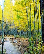
As we started up the trail we came to the first stream crossing. There is a bridge that we have been across several times and this is the first time that I was water running. The bridge crosses a large pipe and so on each side of the bridge you see the pipe and dirt around it. Just below the pipe was the ripple of the water flowing. The vegetation is a little thinner due to fall. I will have to keep my eyes out in the future to see if water is there in the middle of the summer. We made fairly good time going up the trail. We stopped at the same spots at usual to get something to drink. When we started hiking, it took a lot to get Emily to drink and stay hydrated. Now she has no problem drinking a couple of liters while on a hike. Today we noticed that there was la lot of cricket noise at the spring. There were also some new flowers on some of the plants. Also to note was the poison oak, it was losing its leaves for Fall. At the next spat we stop I went to get Emily’s picture. She was giving me her familiar smile and all of a sudden she pointed as I was pushing the button to take the picture. She saw a furry animal. I turned to look and sure enough there was a coyote across the canyon. It would move, stop, and look at us and then move again.
We continued to the top and determined that we would hike the Edison trail for a half mile. The trail has ups and downs as it followed the path of the power lines.
As we got further out we got closer to an uphill portion. We already agreed that we would go to the two mile which is a half mile longer than the Two Trees Trail. Emily was logging the distance on her phone. It would announce when we reached the two mile mark. Emily commented, I am not going to climb that hill as we looked forward. She begged, “Please be two miles soon. We reached the bottom of the hill and her phone said, “Two miles.” She was happy.
We turned around and headed back. When we got back we noted that we went a mile further and it took 18 more minutes than the previous week. It was a good hike and we are going to try to get even quicker in the future. Today, after a long summer, we opened up the air rifle range. It took a few shots to get the cans moving. It was as if the trigger finger was a little rusty. Then again, skippy the squirrel was a little rusty as well. After several attempts to dispatch skippy to the ground with no success, I had to visualize where I was hitting. It was hitting skippy consistently, it was just a little low. With that information, it was no time and skippy was down for the count.
It was a great lunch time and we will be back on the range again soon. Today was somewhat cloudy and there was a lot of moisture in the air. It is beginning to feel like fall. Especially after this past week with some days around one hundred degrees. Emily and I chose the Two Trees trail for today’s hike. We arrived at the trail head and the sun was shrouded by the clouds and had the intensity of a full moon. As we hiked up the trail, the sun began to make it’s way through the clouds. We were surprised that there was water at Cassina Springs as it has been so hot. We did have some rain in the past two weeks and that may have helped out the water situation. There were a lot more birds around the springs than the previous trip when the spring was dry where the tail crosses over the creek. Overall it was a good hike. On the way down we followed a couple of people. To our surprise, the walked past the trail head where we parked. It then dawned on us, college students from UCR as we could see the campus in the distance. Today I went to one of Jacob’s Cross Country meets. There were at least 50 schools there for the meet. He runs in the Freshman-Sophomore group. He ran with the middle sized high school group as Beaumont High is not Large or Small, but Middle size. It was nice to get to see him and the course allowed me to cheer him on in a couple of different spots. Jacob did not that my cheers were not as enthusiastic as they could have been. I would have to admit that there were some fairly over the top parents yelling well wishes at members of various schools runners. Nonetheless, a picture of Jacob as he is on the course.
In my quest to exercise a little, I set forth the goal to climb the highest peaks in the three southern California mountain ranges. First was Mt. San Gorgonio at 11,499 feet in the San Bernardino Mountains. Today was Mt. Baldy, officially known as Mount San Antonio, in the San Gabriel Mountains. Mt. San Jacinto in the San Jacinto Mountains will come later. Mt. Baldy sits at 10,064 feet and has a few different ways to get to the top. The choices for today’s hike were the Bear Canyon trail at 6.4 miles one way with an elevation gain of 5,804 feet. The second was the Baldy Bowl Trail at 4.6 miles one way with an elevation gain of 3,904. The last was either taking the fire service road or riding the ski lift to Baldy Notch and then hiking the Devils Backbone Trail. This route was the same elevation gain, if hiked as the Baldy Bowl Trail. It would be shorter using the ski lift. However, that defeats the purpose of going on a good hike. For this trip a friend was going to accompany me. Mike is moving to Washington state in the next week and Mt. Baldy was still on his list of things to do. We left Riverside at about 6:50 am and started our trek at the trail head at Manker Flats in the San Gabriel Mountains hour later. The hike begins on a paved road past a gate. The paved road leads to San Antonio Falls which is 0.6 miles from the trail head. The falls were small as the snow has long melted.  San Antonio Falls From the falls the road turns back towards the east and is now dirt. As we make our way up the dirt road, we come to an unmarked trail that could easily be passed up. It is the trail we want, so we start making our way up the trail. The trail is fairly steep as it makes its way up. The trail is somewhat shaded in this area and the cool morning air feels good. We also begin to see the valley down below.
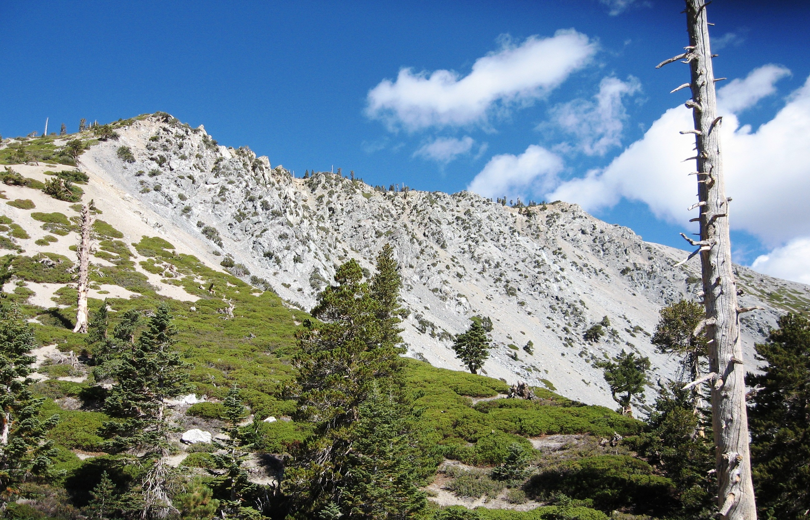
We continue to climb the trail. Soon the Ski Hut comes into view with the large bowl created by chunks of rock breaking off the rock structures from above. The Ski Hut, when we reach it, will mark the 2.5 mile mark. We will have 2.1 more miles to go and we will need to get to the top of that ridge at the top left side of the picture.  Sierra Club Ski Hut At the Ski Hut we take a short break taking in the ominous thought of what was ahead. We head out across the bottom of the bowl meandering through the rocks and boulders. Once we reach the southern side of the bowl we begin climbing a labyrinth of paths that lead up the steep slope of the canyons west wall. Once we reach the ridge the trail levels out to a moderate grade for a period of time. It also gives us a chance to look northward across the bowl.
We continue on a ways and get a view of the top of the ridge above the bowl. Up beyond that ridge is the peak. We continue knowing that soon there is a crazy steep part of the trail. Again, it trail becomes a labyrinth of trails interconnecting. There are also plenty of “micro” switch backs that zig and zag back and forth within about 10 to 15 feet.
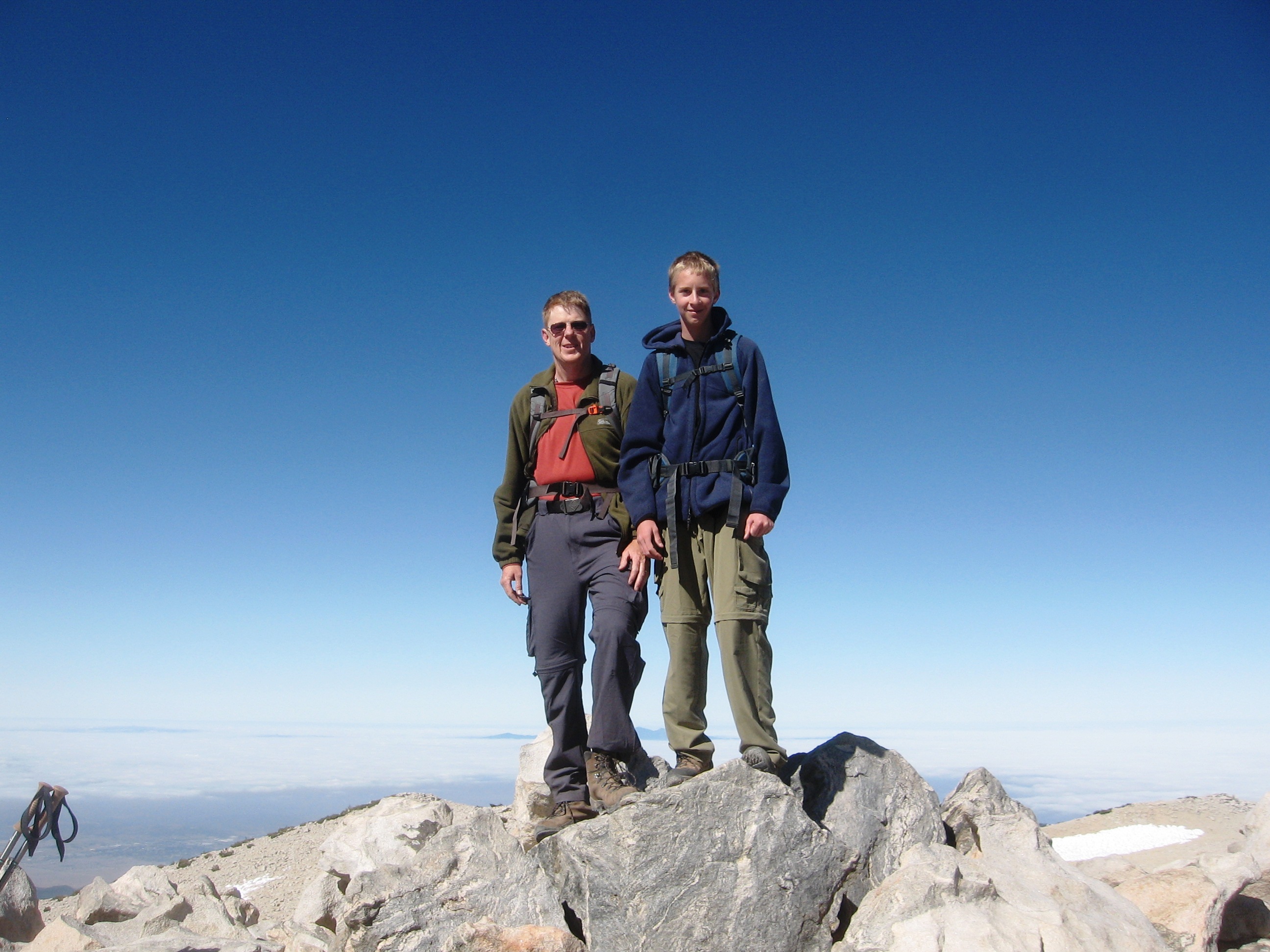
Soon we are on top of the peak for a picture with the marker. We take a few minutes and eat lunch and enjoy the view.
We look around at the views from all directions. The high desert to the north can be seen in the westerly photo showing Mt. Baden Powell.  Looking west towards Mt. Baden Powell from Mt. Baldy In the easterly view, Mt. San Gorgonio and Mt. San Jacinto can be seen in the distance.  Looking East towards Mt. San Gorgonio and Mt. San Jacinto from Mt. Baldy As we left the summit I took a picture looking down San Antonio Canyon towards the south.  Looking south down San Antonio Canyon from Mt. Baldy We made fairly quick time back down the trail. However, we had to be slow and methodical on some of the steeper parts as there was a tendency for our feet to start sliding out from under us due to the steepness. Once on the dirt road we began a fairly brisk walk back to the truck. As we looked back up to the peak, there were a lot of clouds. In fact, San Gorgonio and San Jacinto peaks also accumulated a lot of clouds as well. The weather forecast was 20 percent thunder showers after 11:00 and it looked like there was a higher probability of at least 20 percent than when we were at the peak at noon. The hike was a great hike and I will go back soon. I want to make the hike on a day that will be much clearer. That may be a cold day in November or December when the skies are clear and the visibility is many miles. Before then, I may just find myself on the peak San Jacinto. For the past three Saturdays, I have been hiking somewhere on this planet. This weekend was the work weekend. It started at 7:00 AM trimming the hedge on the one side of the property. Then it was filling in the holes left by Scott’s dogs. Of course, Scott had woken up by this time and offered to help. He loaded up eight trash cans with the green hedge clippings and leaves that I had raked up. For lunch I had a quick bagel with ham and cream cheese prepared by my lovely wife and returned to the fight. By mid afternoon I was ready to stop. My legs felt great. There were other parts of my body that got a better workout this weekend. That is what Shovel Ready is all about. Yesterday was my birthday and a birthday lunch was set up to celebrate. Janet and I met with Scott, Emily and Walter, Emily’s husband at Zacatecas for lunch. There was the obligatory centerpiece with the numbers 50 on it. I wore a necklace with 50’s on it as well. Lunch was good and Emily picked up the tab, $50.50 by chance. It was as if the 50 thing was on a roll. We left Zacatecas and headed home for some Apple Betty, a great apple desert with vanilla ice cream. I had to blow out some candles, including one large 5 and one large 0. Soon after lunch Emily had to leave to go to work and Scott left to meet up with friends. I finished up packing, loaded the truck and had one stop before I started the real birthday event. The stop was to take Eric a plate with some of the desert on it to his workplace. Then I was on the road. I let everyone know that they could come with me and celebrate my 50th at about 10 thousand feet. I had no takers. It was about an hour dive to the forest service road where I got off the highway. The dirt forest service road to the Fish Creek trail head was rougher than usual. We had a big storm the past week where there was a lot of rain and hail in the San Gorgonio wilderness. I never really account for the time it takes on the dirt road.
Once I reached the trail head I grabbed my backpack and headed out. It was 6:00 in the evening and the sun was lower in the sky than I really wanted to see. I meet a deer hunter in his camouflage clothing carrying his bow in search of some meat for his freezer. The beginning of the trail is fairly easy, because it is downhill. Jacob told me, with a big grin, to enjoy the last 0.6 miles of my trip as they would be uphill on the way out. Soon enough I was going uphill.
I made it past Fish Creek camp which was 1.8 miles from the trailhead and headed past the spring so I could pick up a couple more liters of water. Once I got my water, I put may backpack on and took a few steps when I realized it had gotten dark. I had about 2.5 miles more to go. I took my backpack off, got my headlamp out as well as my jacket and knit cap. I know that it would be getting cooler with the sun down. It was so dark; the water in the stream cannot even be seen with the poor flash in the BlackBerry.
As I made my way up hill it was quiet. All I could hear was my heartbeat, breathing and the noise that my feet and hiking posed were making. When I stopped, it was extremely quiet. No one was around. In fact, it was difficult to see the trail. No one had traveled the trail after the storms the past week. In places the trail seemed to disappear or at least become extremely faint. I would have been more comfortable if I had someone along for the trek. I did know that Ron would be a couple of hours behind me in the trail, so If I needed some type of help, he would be available. Soon enough I arrived at Fish Creek Saddle. I put up the tent that I rented. It would have helped to put it together once in the light, but it went together quick enough. I packed my daypack for the trip to the peak. I was in my tent at 10:00 and soon enough falling asleep. I did wake up to the crunching of decomposed granite under the foot of a hiker coming up the trail. Ron arrived at 11:15.
The sun started lighting up the mountains around Dry Lake. It is a little different looking at dry lake from this vantage point this early in the morning. It reminded me of when Jacob and I were at Dry Lake taking pictures as the sun came up.
As we traveled the trail, we came across places that looked like snow. It actually was piles of hail from the storm a couple of days before.
As we got closer to the top, I took a picture of Dragons Head peak with the cloud cover over Banning in the background. One of these days I want to get to the top of Dragons Head along with a few other peaks in the area.
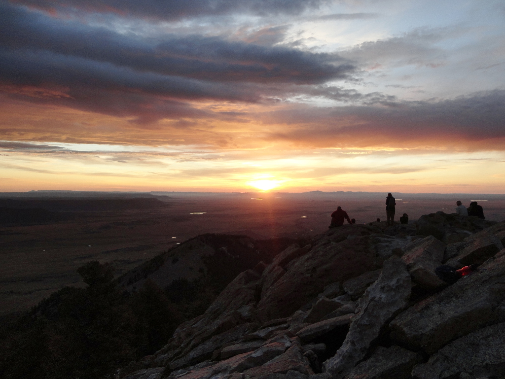
Once we reached the top, about 9:30 in the morning, we sat down in a ten by ten area enclosed by a small rock wall. This is the place where we signal the other mountain tops. As we were waiting, one of the first things we heard on the HAM radio was, KJ6RDH, KJ6RDH, KJ6KQE. I told Ron, I believe that is for me. One of Janet’s coworker’s husbands is a HAM operator. I let Janet know that he could reach me on the radio in the morning so that she would know that I made it through the night and up to the top of Mt. San Gorgonio. The view from the top was like looking down on clouds. Sticking out of the clouds in the distance is Santiago Peak. I guess that is what you see when you are at 11,499 feet above sea level.
We signaled Mt. Baden Powell and a group at Little Baldy for Operation On Target, a Boy Scout activity. The group at Little Baldy needed to hike some more to get to the tip of Mt. Baldy. While we waited, we took time for an early morning nap. When you are 50, what is wrong with and early morning nap?
About 20 minutes after noon we started our trek back to Fish Creek Saddle to get the rest of our gear. From the top, we had 11.5 miles to get back to the trail head. The hike down went fairly well. Both of us were getting tired. Then of course, there is the last 0.6 miles of uphill to the trail head. We arrived at the trail head ad 5:45. Then there was the drive back to the highway.
Once I got on the highway, I thought to myself, in less than 24 hours I have traveled 23 miles on foot and slept on the ground at about 10 thousand feet. What a wonderful way to start the next 50. Today Emily and I had a little time crunch. We could not go on a far far away hike so we chose to do Two Trees. It was cloudy as we arrived at the trail head. The radio said that there were thundershowers in Orange County. We had ponchos if we saw rain, so we headed out. After we got to the top we decided to go find a geocache. We reached the place where the geocache was supposed to be and looked around. We did not find it. We found a trail back to so that we did not need to bushwhack like we did to get there. We headed down the trail and were glad we were out doing something rather than sitting in the haze and fog below.
Today Emily and I had the chance to explore a now trail. We arrived at the trail head later than we would have liked to. All the parking spots were gone and we were left to park on the side of the road. No problem, dive a truck and park at extreme angles at the side of he road. The first part of the Ice House Canyon trail is a road, or should I say, a driveway for some cabins that are located up the canyon. The trail is well maintained and there is plenty of shade for the first mile and a half. Trail follows runs along side a stream that runs through the canyon. There are plenty of trees as well. The stream has plenty of water, which surprised me for this late in the year. On our way back down the trail later in the day, the stream had several people in it or sitting by it. This was mostly in the first mile up the canyon. IT looked like plenty of people wanted in the cool stream in the shade on a hot summer day. It seemed the the stream was fed from springs. We had noticed a few places on the trail where water seemed to be seeping our or running out of the sides of the canyon. As we got higher up the canyon, the stream beds we could see were dry. There is one spring further up the trail from where we stopped for lunch that runs almost year long.
Lunch was mini pita pockets with your choice of pepper jack, Swiss or cheddar cheese as well as peperoni or salami. We ate lunch and relaxed in the shade of white fur and incense cedar trees just past the two mile marker. Once lunch was over, we headed back down the trail. It was about noon and people were traveling up the trail. It was getting hot it was nice when we got back to the stream area with all the trees and shade.
It was a great hike and one we are going to do again. We will start earlier as we went to get all the way up to Ice House Saddle and possibly to one or more of the nearby peaks. Went for a walk tonight. I got a couple of blocks and decided that walking would not burn enough calories and it would take to long to get any real exercise. Started running. Once I started running I never stopped until I got back to the house. The total trip was 2.2 miles in 23 minutes. It was my first real exercise in a month as Philmont was the last real exercise that I did. Got to keep it up as there are a few more peaks in southern California that I want to get to the top of. Tonight was our last summer sailing evening.  Sailing on Lake Evans We sailed ever Thursday evening for the last 3 months. This was the first evening that I sailed in the month of August. I am sorry to see the evening sailing over. The days are getting shorter and the breeze stalls out as the sun gets lower in the sky. I may have to resort to Saturday afternoons. |
 |
||||||||||||||||


